Flooding and water quality
Causes and trends
 More frequent, heavy rainfall means more flooding. Hennepin County is experiencing a significant increase in the number of 2-, 3- and even 4-inch rainfall events.
Heavy rainfall contributes to increased flash flooding. Sustained high levels of precipitation can increase groundwater flooding, and higher groundwater levels pose threats to water quality.
In addition, warmer winters have led to an increase in freeze/thaw events.
Impacts and threats
Increased flooding events can endanger lives, destroy property and belongings, disrupt vital services, and hinder the ability of emergency response vehicles to respond to calls.
Buildings in persistently saturated soils are more likely to grow mold and bacteria that reduce indoor air quality and pose respiratory threats to people in the buildings.
Rising groundwater levels may pose a risk to local water quality when it intersects with septic systems, petroleum tanks, areas of historic contamination, plumes, and vapors.
Increases in freeze/thaw events negatively impact pavement systems and accelerate infrastructure deterioration.
Who is more at risk
The ability of property owners and residents to respond and recover from flood impacts varies greatly. For some residents and businesses, flooding may be an inconvenience or a manageable problem. For others, such as a small business or a low-income family, flooding is potentially catastrophic. Beyond property damage, flooding also can lead to mold-related health impacts, waterborne diseases, and stress.
Saturated soils disproportionately impact residents living and working in areas prone to groundwater flooding. These residents may not realize they are at risk. Until recently, those getting flood insurance were mostly property owners and residents in Federal Emergency Management Agency (FEMA)-designated floodplains. Recently with the increasing frequency and intensity of heavy rainfall, nearly one-quarter of flood damage and one-third of flood recovery costs occur outside of the FEMA-designated floodplains, making it clear that wherever it can rain, it can also flood.
Areas susceptible to flooding
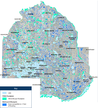
The locations on this map in dark blue are low spots identified by the Met Council that are susceptible to localized flash flooding from high-intensity rainfall based on topography. This analysis was conducted, in part, to examine risks from localized flooding that FEMA mapping (identified in teal) doesn’t consider.
This Met Council “Blue Spot” data does not consider the varying capacity of these locations to drain, either through stormwater drains or soil infiltration. However, most stormwater conveyance systems were designed based on outdated precipitation models, meaning these areas are likely at risk for flash flooding.